Toronto, Ontario (30 October 2023) – Class 1 Nickel and Technologies Ltd. (CSE: NICO | OTCQB: NICLF) (“Class 1 Nickel” or the “Company”) is pleased to announce the results of its 2022-2023 exploration program (diamond drilling, Borehole EM, surface TDEM, Drone Mag-LiDAR) on its Somanike Nickel Sulphide Project (“Somanike” or the “Project”) in the central Abitibi Region of Québec. The 6,882 ha (148 mining claims) Project, acquired by the Company in early 2021, is located about 25 km north of the mining centre of Malartic, 40 km northwest of Val-d’Or, and 60 km east of Rouyn-Noranda includes the historical Marbridge Ni-Cu Mine which closed in 1968 (Figure 1).
2022-2023 Drilling (true width) and Exploration Highlights:
- NICO22-022: 0.7 m @ 2.29% Ni from 69.5 m.
- NICO22-048: 1.0 m @ 2.30% Ni from 474.6 m.
- NICO22-049: 0.7 m @ 3.11% Ni from 598.7 m and 0.7 m @ 1.64% Ni from 601.0 m.
- NICO22-025: 0.6 m @ 1.35% Ni from 12.0 m.
- NICO22-038: 1.9 m @ 0.93% Ni from 321.0 m including 0.14 m @ 6.21% Ni.
- NICO22-038: 0.2 m @ 2.03% Ni from 334.4 m.
- NICO22-033: 1.5 m @ 1.53% Ni from 150.0 m including 0.75 m @ 2.28% Ni.
- NICO22-036: 3.5 m @ 1.07% Ni from 76.0 m including 1.60 m @ 1.48% Ni.
- Exploration drill hole NICO22-017 intersected 0.48% Ni over 1.0 m.
- Mine 1 Horizon extended to the southeast and open on geophysical evidence.
- Four (4) new and untested off-hole BHEM targets generated within the Mine 1 mineralized sequence and its footwall.
David Fitch, President & CEO of Class 1 Nickel, stated, “We are very pleased to have completed and received results from the first comprehensive drilling program which targeted areas below and adjacent to the four known mineralized zones at the historical Marbridge Ni-Cu Mine. The combined use of modern airborne, surface, and borehole geophysics has successfully demonstrated their viability in targeting new and existing areas of sulphide mineralization, providing us with immediate targets for the next phase of drilling. We know from the drilling to date that we are in a very fertile geological environment with abundant ultramafic rocks that host significant grades of nickel along with copper and PGE sulphide mineralization.”
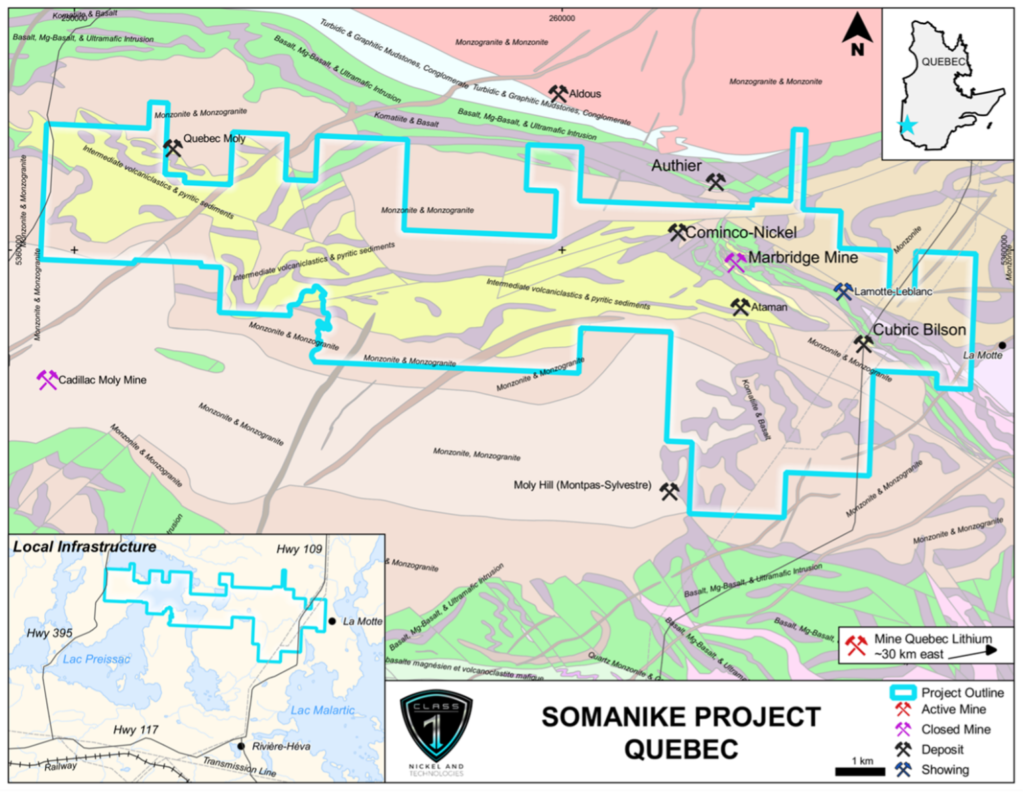
Figure 1: Location of the Somanike Nickel Sulphide Project near the City of Val-d’Or, Quebec (geology modified from Pilot et al., 2014).
The 40-hole, 16,510 m diamond drilling program (see Company news release dated 8 February 2023) was designed to explore for nickel, copper, platinum, and palladium sulphide mineralization utilizing its comprehensive historical database, a historical 2014-2015 Project-wide VTEM airborne geophysical survey, and ground TDEM geophysical surveys (see Company news release dated 14 July 2022). Of the 40 diamond drill holes, 6 aimed at crown pillar tests on M1 and M2 hit openings, 30 holes successfully tested the extensions to mineralization in the vicinity of the historical Marbridge Mine, and 4 holes tested regional exploration targets northwest of the Marbridge area (Figure 2 and Figure 3).
A summary of most significant intersections from the 2022 Phase 1 diamond drilling program are provided in Table 1 and a more extensive list of selected intersections in Table 2. A summary of the drill hole parameters, including collar locations, is provided in Table 3 and a detailed location map of drill hole collars and traces with generalized geology is shown in Figure 3.
Single and multiple intersections of nickel sulphide mineralization (intercepts of >0.40% Ni) were encountered in 17 drill holes (Table 1), and all 40 holes intersected ultramafic rocks which are the recognized host rocks to the target sulphide mineralization.
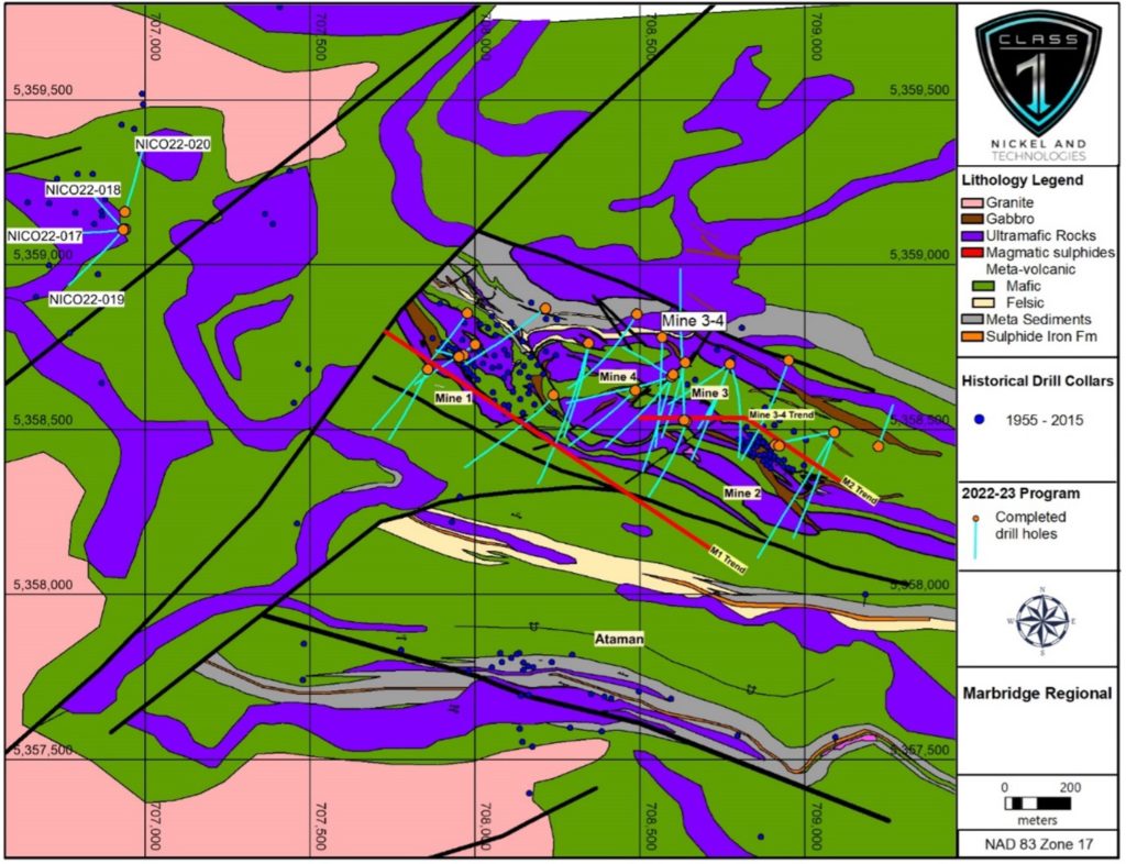
Figure 2: Generalized geology and location of 2022 diamond drill hole collars and traces in the historical Marbridge Ni-Cu Mine region and the La Motte Ultramafic Complex (bedrock geology from Adair, 2016 Rapport de Travaux 2016).
The drilling program extended the Mine 1 Horizon (Figure 3 and Figure 4) 350 m to the southeast of historical mineralization where 3 new geophysical target areas were generated as off-hole Borehole EM (BHEM) responses (Figure 5). An additional untested off-hole BHEM anomaly was detected in ultramafic rocks approximately 100 m lower in the stratigraphy than existing mineralization in the Mine 1 Horizon (Figure 5). All of the BHEM geophysical targets are considered high priority and remain untested.
The Mine 2 Horizon (Figure 6) and Mine 3-4 horizons (Figure 7) sit structurally above the Mine 1 Horizon; results of the drilling program and geophysical investigation showed potential to connect mineralization between Mine 2 and Mine 3 and to extend Mine 4 at depth below 150 metres. Potential exists to connect these with Mine 1 at depth.
Composite calculations from core assay results (Table 1, Table 2 and Table 3) use a 0.40% Ni minimum grade cut-off applied to individual assay intervals. Zone names are based on the historical Marbridge Mine horizons and were assigned based on 3D models of historical drill-intercepts in each mineralized horizon. Holes not listed in Table 1 did not intersect significant mineralization or intersected mine openings.
The drilling program was contracted to Forage GeoNord from Dolbeau-Mistassini, Québec and Forage LaMontagne Fortier from Rouyn-Noranda, Québec, and completed under the supervision of ABG Exploration Inc. (Alex Belo Géologue Inc.) of Amos, Québec.
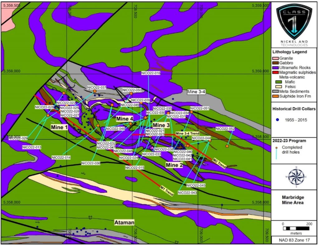
Figure 3: Location of drill hole collars and traces from the 2022 Phase 1 drilling program with generalized geology of the Marbridge Ni-Cu Mine area and the La Motte Ultramafic Complex (bedrock geology from Adair, 2016 Rapport de Travaux 2016).
Table 1. Selected diamond drill hole intersections from 2022 Phase 1 drilling (core assay composites).
| Drill Hole | From (m) | To (m) | Length (m) | Width (m)* | Ni (%) | Cu (%) | Pt (g/t) | Pd (g/t) | Au (g/t) | Zone |
| NICO22-022 | 153.0 | 155.0 | 2.0 | 2.0 | 0.77 | 0.04 | 0.13 | 0.50 | 0.02 | M1-Footwall |
| NICO22-014 | 193.2 | 194.7 | 1.5 | 1.3 | 0.67 | 0.07 | 0.00 | 0.00 | 0.00 | M1 |
| NICO22-022 | 69.5 | 70.2 | 0.7 | 0.7 | 2.29 | 0.11 | 0.00 | 0.00 | 0.00 | M1 |
| NICO22-036 | 365.9 | 366.2 | 0.3 | 0.3 | 0.94 | 0.02 | 0.00 | 0.00 | 0.04 | M1 |
| NICO22-037 | 181.0 | 182.0 | 1.0 | 1.0 | 0.49 | 0.01 | 0.00 | 0.00 | 0.00 | M1 |
| NICO22-047 | 326.8 | 331.1 | 4.3 | 2.0 | 0.70 | 0.06 | 0.03 | 0.03 | 0.03 | M1 |
| and | 338.9 | 340.0 | 1.1 | 0.5 | 0.85 | 0.04 | 0.08 | 0.12 | 0.05 | M1 |
| NICO22-048 | 466.3 | 467.9 | 1.6 | 1.5 | 0.76 | 0.03 | 0.04 | 0.09 | 0.02 | M1 |
| including | 466.3 | 466.8 | 0.5 | 0.5 | 1.50 | 0.05 | 0.05 | 1.70 | 0.03 | M1 |
| and | 469.5 | 469.8 | 0.3 | 0.3 | 0.83 | 0.04 | 0.07 | 0.08 | 0.00 | M1 |
| and | 474.6 | 475.7 | 1.1 | 1.0 | 2.30 | 0.10 | 0.10 | 0.17 | 0.05 | M1 |
| NICO22-049 | 598.7 | 599.7 | 1.0 | 0.7 | 3.11 | 0.17 | 0.28 | 0.30 | 0.09 | M1 |
| and | 601.0 | 602.0 | 1.0 | 0.7 | 1.64 | 0.25 | 0.17 | 0.34 | 0.05 | M1 |
| NICO22-050 | 425.4 | 426.8 | 1.4 | 1.3 | 0.81 | 0.07 | 0.05 | 0.13 | 0.03 | M1 |
| and | 453.5 | 455.0 | 1.5 | 1.4 | 0.88 | 0.05 | 0.10 | 0.13 | 0.00 | M1 |
| NICO22-025 | 12.0 | 12.6 | 0.6 | 0.6 | 1.35 | 0.00 | 0.26 | 0.19 | 0.08 | M1-open stope |
| NICO22-051 | 270.0 | 270.5 | 0.5 | 0.4 | 0.52 | 0.00 | 0.12 | 0.14 | 0.02 | M2 |
| NICO22-038 | 334.4 | 334.9 | 0.5 | 0.2 | 2.03 | 0.12 | 0.00 | 0.00 | 0.00 | M3 |
| and | 336.7 | 338.7 | 2.0 | 1.0 | 0.54 | 0.03 | 0.00 | 0.00 | 0.02 | M3 |
| and | 425.6 | 426.4 | 0.8 | 0.4 | 0.79 | 0.02 | 0.06 | 0.06 | 0.01 | M3 |
| NICO22-047 | 326.8 | 331.1 | 4.3 | 2.0 | 0.70 | 0.06 | 0.03 | 0.03 | 0.03 | M1 |
| NICO22-016 | 92.0 | 93.0 | 1.0 | 0.7 | 0.49 | 0.01 | 0.04 | 0.00 | 0.00 | M3 |
| and | 96.0 | 100.0 | 4.0 | 2.6 | 0.56 | 0.01 | 0.06 | 0.01 | 0.00 | M3 |
| NICO22-021 | 126.0 | 127.0 | 1.0 | 0.5 | 0.43 | 0.02 | 0.03 | 0.06 | 0.01 | M3 |
| and | 129.5 | 130.0 | 0.5 | 0.3 | 0.48 | 0.07 | 0.04 | 0.28 | 0.02 | M3 |
| NICO22-023 | 143.0 | 144.0 | 1.0 | 0.4 | 0.77 | 0.01 | 0.01 | 0.09 | 0.02 | M3 |
| NICO22-031 | 177.0 | 178.0 | 1.0 | 0.6 | 0.43 | 0.01 | 0.05 | 0.02 | 0.00 | M3 |
| and | 203.0 | 204.0 | 1.0 | 0.6 | 0.44 | 0.00 | 0.01 | 0.00 | 0.00 | M3 |
| and | 210.0 | 213.0 | 3.0 | 1.8 | 0.40 | 0.01 | 0.37 | 0.06 | 0.00 | M3 |
| and | 218.0 | 219.0 | 1.0 | 0.6 | 0.48 | 0.02 | 0.02 | 0.00 | 0.00 | M3 |
| NICO22-033 | 150.0 | 152.0 | 2.0 | 1.5 | 1.53 | 0.00 | 0.07 | 0.11 | 0.17 | M3 |
| including | 150.0 | 151.0 | 1.0 | 0.75 | 2.28 | 0.00 | 0.05 | 0.13 | 0.29 | M3 |
| and | 159.0 | 161.0 | 2.0 | 1.5 | 0.53 | 0.00 | 0.04 | 0.04 | 0.05 | M3 |
| and | 166.0 | 170.0 | 4.0 | 3.0 | 0.51 | 0.01 | 0.02 | 0.01 | 0.02 | M3 |
| and | 173.0 | 174.0 | 1.0 | 0.8 | 0.71 | 0.02 | 0.00 | 0.00 | 0.00 | M3 |
| NICO22-038 | 321.0 | 325.0 | 4.0 | 1.9 | 0.93 | 0.03 | 0.01 | 0.00 | 0.01 | M3 |
| including | 321.8 | 322.1 | 0.3 | 0.14 | 6.21 | 0.09 | 0.00 | 0.00 | 0.00 | M3 |
| and | 334.4 | 334.9 | 0.5 | 0.2 | 2.03 | 0.12 | 0.00 | 0.00 | 0.00 | M3 |
| and | 336.7 | 338.7 | 2.0 | 1.0 | 0.54 | 0.03 | 0.00 | 0.00 | 0.00 | M3 |
| and | 425.6 | 426.4 | 0.8 | 0.4 | 0.79 | 0.02 | 0.10 | 0.10 | 0.00 | M3 |
| NICO22-049 | 198.0 | 201.0 | 3.0 | 1.3 | 0.61 | 0.00 | 0.21 | 0.17 | 0.02 | M3 |
| and | 214.0 | 225.0 | 11.0 | 4.4 | 0.78 | 0.00 | 0.07 | 0.10 | 0.02 | M3 |
| NICO22-036 | 76.0 | 80.5 | 4.5 | 3.5 | 1.07 | 0.05 | 0.08 | 0.13 | 0.02 | M4 |
| including | 76.5 | 77.0 | 0.5 | 0.4 | 1.72 | 0.14 | 0.23 | 0.00 | 0.00 | M4 |
| including | 78.5 | 80.5 | 2.0 | 1.6 | 1.48 | 0.05 | 0.10 | 0.00 | 0.00 | M4 |
Table 2. Summary of high-grade nickel intersections from 2022 Phase 1 drilling (core assay composites).
| Drill Hole | From (m) | To (m) | Length (m) | Width (m)* | Ni (%) | Cu (%) | Pt (g/t) | Pd (g/t) | Au (g/t) | Zone |
| NICO22-022 | 69.50 | 70.20 | 0.70 | 0.70 | 2.29 | 0.11 | 0.00 | 0.00 | 0.00 | M1 |
| NICO22-048 | 466.30 | 466.80 | 0.50 | 0.50 | 1.50 | 0.05 | 0.05 | 1.70 | 0.03 | M1 |
| and | 474.60 | 475.70 | 1.10 | 1.00 | 2.30 | 0.10 | 0.10 | 0.17 | 0.05 | M1 |
| NICO22-049 | 598.70 | 599.70 | 1.00 | 0.70 | 3.11 | 0.17 | 0.28 | 0.30 | 0.09 | M1 |
| and | 601.00 | 602.00 | 1.00 | 0.70 | 1.64 | 0.25 | 0.17 | 0.34 | 0.05 | M1 |
| NICO22-025 | 12.00 | 12.60 | 0.60 | 0.60 | 1.35 | 0.00 | 0.26 | 0.19 | 0.08 | M1-open stope |
| NICO22-038 | 334.40 | 334.90 | 0.50 | 0.20 | 2.03 | 0.12 | 0.00 | 0.00 | 0.00 | M3-Footwall |
| NICO22-033 | 150.00 | 152.00 | 2.00 | 1.50 | 1.53 | 0.00 | 0.07 | 0.11 | 0.17 | M3 |
| including | 150.00 | 151.00 | 1.00 | 0.75 | 2.28 | 0.00 | 0.05 | 0.13 | 0.29 | M3 |
| NICO22-038 | 321.80 | 322.10 | 0.30 | 0.14 | 6.21 | 0.09 | 0.00 | 0.00 | 0.00 | M3 |
| NICO22-036 | 76.00 | 80.50 | 4.50 | 3.50 | 1.07 | 0.05 | 0.08 | 0.13 | 0.02 | M4 |
| including | 76.50 | 77.00 | 0.50 | 0.40 | 1.72 | 0.14 | 0.23 | 0.00 | 0.00 | M4 |
| including | 78.50 | 80.50 | 2.00 | 1.60 | 1.48 | 0.05 | 0.10 | 0.00 | 0.00 | M4 |
Table 3. Summary of 2022 Phase 1 diamond drill hole parameters (NAD83, Zone 17N).
| Drill Hole | UTM_X (mE) | UTM_Y (mN) | Elevation (m) | Length (m) | Az | Dip |
| NICO22-013 | 707857 | 5358683 | 314.86 | 397 | 215 | -55 |
| NICO22-014 | 708238 | 5358606 | 315.5 | 834 | 210 | -70 |
| NICO22-015 | 708641 | 5358526 | 319.31 | 585 | 200 | -67 |
| NICO22-016 | 708634 | 5358530 | 319.97 | 615 | 0 | -45 |
| NICO22-017 | 706940 | 5359108 | 314.66 | 446 | 260 | -70 |
| NICO22-018 | 706935 | 5359109 | 315.17 | 288 | 317 | -65 |
| NICO22-019 | 706934 | 5359107 | 314.89 | 483 | 220 | -65 |
| NICO22-020 | 706939 | 5359161 | 315.69 | 318 | 20 | -50 |
| NICO22-021 | 708634 | 5358529 | 319.59 | 192 | 0 | -55 |
| NICO22-022 | 708001 | 5358759 | 320.41 | 303 | 235 | -45 |
| NICO22-023 | 708634 | 5358529 | 319.64 | 352 | 0 | -60 |
| NICO22-024 | 708596 | 5358661 | 316.54 | 455 | 195 | -50 |
| NICO22-025 | 707965 | 5358726 | 319.78 | 37 | 215 | -45 |
| NICO22-026 | 707965 | 5358726 | 319.7 | 36 | 215 | -60 |
| NICO22-027 | 707951 | 5358722 | 319.73 | 150 | 215 | -65 |
| NICO22-028 | 707950 | 5358722 | 319.61 | 153 | 285 | -65 |
| NICO22-029 | 707977 | 5358854 | 324.26 | 660 | 215 | -50 |
| NICO22-030 | 708637 | 5358704 | 319.8 | 357 | 195 | -50 |
| NICO22-031 | 708773 | 5358701 | 317.24 | 321 | 200 | -55 |
| NICO22-032 | 708345 | 5358764 | 317.41 | 585 | 190 | -60 |
| NICO22-033 | 708773 | 5358700 | 317.35 | 426 | 200 | -45 |
| NICO22-034 | 708773 | 5358701 | 317.2 | 486 | 200 | -65 |
| NICO22-035 | 708773 | 5358701 | 317.3 | 423 | 235 | -60 |
| NICO22-036 | 708345 | 5358764 | 317.54 | 603 | 200 | -45 |
| NICO22-037 | 708213 | 5358869 | 320.12 | 539 | 230 | -60 |
| NICO22-038 | 708773 | 5358701 | 317.32 | 666 | 160 | -65 |
| NICO22-039 | 708567 | 5358780 | 317.47 | 495 | 180 | -50 |
| NICO22-040 | 708909 | 5358455 | 314.8 | 21 | 195 | -45 |
| NICO22-041 | 708922 | 5358451 | 314.82 | 34.2 | 195 | -60 |
| NICO22-042 | 708922 | 5358452 | 314.72 | 46 | 195 | -85 |
| NICO22-043 | 709089 | 5358493 | 314.79 | 594 | 210 | -45 |
| NICO22-044 | 709090 | 5358494 | 314.82 | 398 | 260 | -65 |
| NICO22-045 | 709090 | 5358492 | 314.8 | 492 | 200 | -50 |
| NICO22-046 | 708596 | 5358662 | 316.73 | 708 | 250 | -67 |
| NICO22-047 | 708487 | 5358620 | 317.93 | 444 | 227 | -55 |
| NICO22-048 | 708600 | 5358667 | 316.69 | 749 | 215 | -70 |
| NICO22-049 | 708598 | 5358664 | 316.98 | 741 | 295 | -80 |
| NICO22-050 | 708490 | 5358851 | 317.78 | 606 | 210 | -62 |
| NICO22-051 | 708951 | 5358710 | 314.75 | 501 | 200 | -50 |
| NICO22-052 | 709222 | 5358449 | 310.65 | 201 | 20 | -50 |
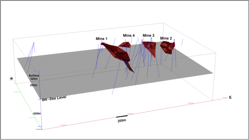
Figure 4: 3D overview of the drill holes (blue traces) completed in 2022 Phase 1 with the four (4) modelled mineralized zones (Mine 1, 2, 3, and 4 in red) in the area of the historical Marbridge Ni-Cu Mine (looking northeast).
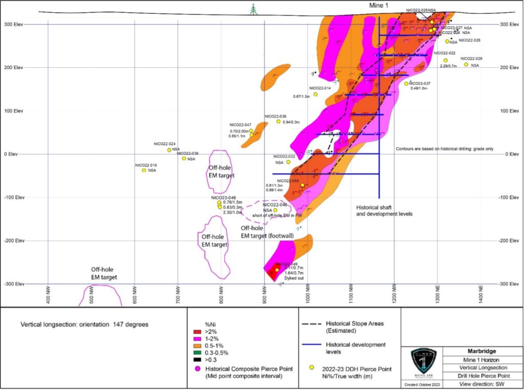
Figure 5: Vertical long-section of the Mine 1 Horizon (147Az – looking southwest) with 2022 drill hole pierce points (Ni%/true width) and the location of the 4 untested off-hole BHEM targets (“Off-hole EM target”), within the area of the historical Marbridge Ni-Cu Mine (NSA = no significant assays).
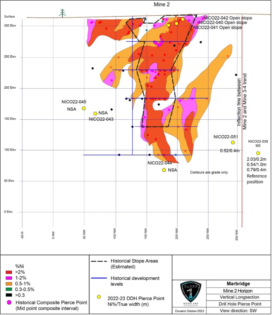
Figure 6: Vertical long-section of the Mine 2 Horizon (127Az section – looking southwest) with 2022 drill hole pierce points (Ni%/true width) within the area of the historical Marbridge Ni-Cu Mine (NSA = no significant assays).
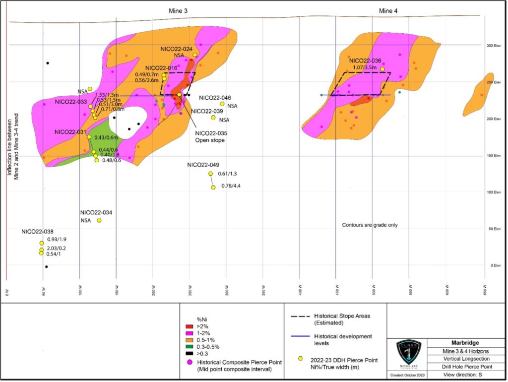
Figure 7: Vertical long-section of the Mine 3-4 horizons (97Az section – looking south) with 2022 drill hole pierce points (Ni%/true width) within the area of the historical Marbridge Ni-Cu Mine (NSA = no significant assays).
Exploration Potential and Next Steps
Given the positive results from the 2022 diamond drilling program (see Company news releases 23 August 2022 and 8 February 2023) and the new interpretation and targets that have been developed through geophysics (airborne VTEM, surface TDEM and Borehole EM), the Company has an abundance of opportunities to move the project forward by way of a number of exploration initiatives including:
- 3D geological model updates and interpretation.
- surface TDEM geophysical surveys including in-fill survey of previous area and new areas.
- new HeliTEM survey in areas of the Property net yet covered by 2014-2015 survey.
- 3D Induced Polarization combined with Magnetotellurics to develop deeper drill targets.
- drill-testing of off-hole 3D-BHEM anomalies in the Mine 1 Horizon.
- drilling within the gap between the Mine 2 and Mine 3-4 horizons.
- additional exploration drilling to test anomalies outside of the Marbridge Mine area.
QA/QC and Assay Protocols
All core and QAQC samples from the drilling program were sent to Impact Global Solutions Inc.’s laboratory in Delson, Québec (“IGS”) for analysis by a 50 element assay package of 4 Acid Digestion, Ore Grade Metals Package, with ICP-OES finish and precious metals (Pt, Pd, Au) by fire assay. IGS is recognized by the industry and accredited ISO/MEC 17025 by the Standards Council of Canada. In addition to the QA/QC employed by IGS, Class 1 Nickel uses its own rigorous QA/QC protocols for sampling which includes the insertion of certified reference material standards, sample duplicates, and coarse silica blanks into the sample stream on a systematic basis.
Qualified Person
The technical information in this news release has been reviewed and approved by Alexandr Beloborodov (P.Geo.), geological consultant to the Company, who is a Qualified Person under the definitions established by National Instrument 43‐101.
About Somanike Nickel Sulphide Project
The Somanike Nickel Sulphide Project is located in the prolific and mining-friendly Abitibi Region of northwestern Quebec approximately 25 km north of the mining centre at Malartic, 40 km northwest of Val-d’Or, and 60 km east of Rouyn-Noranda. The Project consists of 148 mining titles (6,882 ha) over the large northwest-trending La Motte Ultramafic Complex, within the Abitibi Greenstone Belt. The ultramafic rocks host several nickel sulphide occurrences, recognized nickel targets (geophysical and geological), and areas of historical high-grade nickel production (Marbridge Ni-Cu Mine).
The Somanike Nickel Sulphide Project includes Quebec’s first nickel mine, the historical Marbridge Ni-Cu Mine (the “Marbridge”), operated by Falconbridge Nickel from 1962 to 1968, which produced high-grade nickel and secondary copper. The Marbridge occurs within the northwest-trending La Motte Ultramafic Complex which comprises deformed and altered ultramafic rocks. Falconbridge Nickel reported production of 702,366 tons grading 2.28% Ni and 0.10% Cu, prior to being placed on care and maintenance in 1968 (source: SIGEOM, MERN Quebec Government website).
The Marbridge consists of two shafts that accessed four separate mineralized zones (horizons) over a combined strike length of 1,000 metres. During production, mineralized material was trucked 25 km south to the Canadian Malartic processing plant. Mining in 1968 ceased in mineralization and the four nickel sulphide zones or mineralized horizons (Mine 1, Mine 2, and Mine 3-4) remain open to expansion along strike and down-dip/plunge.
About Class 1 Nickel
Class 1 Nickel and Technologies Limited (CSE: NICO | OTCQB: NICLF) is a Mineral Resource Company focused on the exploration and development of its 100% owned komatiite-hosted Somanike Ni-Cu Sulphide Project in Quebec, which includes the historical Marbridge Ni-Cu Mine. The Company also owns the Alexo-Dundonald Ni-Cu-Co Sulphide Project, a portfolio of komatiite-hosted magmatic sulphide deposits located near Timmins, Ontario.
For more information, please contact:
Mr. David Fitch, President & CEO
T: +61.400.631.608
For additional information please visit our website at www.class1nickel.com and our Twitter feed: @Class1Nickel.
Neither the Canadian Securities Exchange nor its regulation services provider has reviewed or accepted responsibility for the adequacy or accuracy of this press release.
This news release contains forward-looking information which is not comprised of historical facts. Forward-looking information is characterized by words such as “plan”, “expect”, “project”, “intend”, “believe”, “anticipate”, “estimate” and other similar words, or statements that certain events or conditions “may” or “will” occur. Forward-looking information involves risks, uncertainties and other factors that could cause actual events, results, and opportunities to differ materially from those expressed or implied by such forward-looking information. Factors that could cause actual results to differ materially from such forward-looking information include, but are not limited to, changes in the state of equity and debt markets, fluctuations in commodity prices, delays in obtaining required regulatory or governmental approvals, and other risks involved in the mineral exploration and development industry, including those risks set out in the Company’s management’s discussion and analysis as filed under the Company’s profile at www.sedar.com. Forward-looking information in this news release is based on the opinions and assumptions of management considered reasonable as of the date hereof, including that all necessary governmental and regulatory approvals will be received as and when expected. Although the Company believes that the assumptions and factors used in preparing the forward-looking information in this news release are reasonable, undue reliance should not be placed on such information. The Company disclaims any intention or obligation to update or revise any forward-looking information, other than as required by applicable securities laws.